 The High Sierra Trail had been on my mind since our failed attempt six years earlier. Our year of training was over, and the time to see if it would pay off had arrived. California, here we come again!
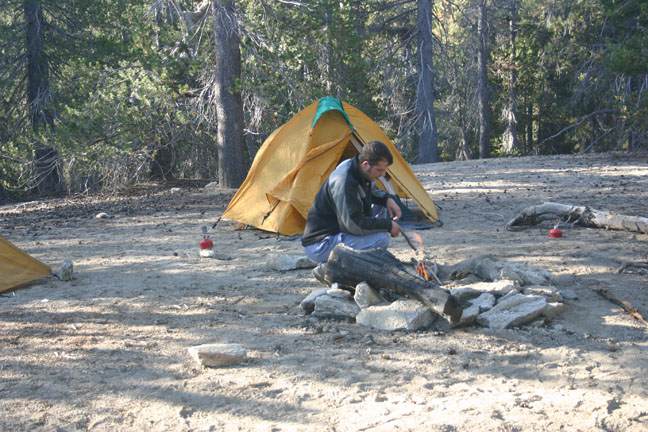
As we had made the drive to California several times before, the drive was fairly uneventful, and was mostly spent assuring ourselves that we were ready. Rather than a motel, we decided to camp in Sequoia National Park, as they have free wilderness camping (you just need to get a free fire permit). Camping at this height would help us to acclimatize and make the next morning a bit easier.
The first good sign on day one was being able to put our packs on without help. They were laden with 7 days of food and lots of water, but still weighed less than half the previous attempt. In the Crescent Meadow parking lot we met a few happy British folks and had a brief chat about our itineraries. It turns out we had both visited the same NPS Web site (unfortunately no longer available), and had identical plans. Company is always nice, especially two or three pleasant looking chaps from England, Ian and I's country of birth.
 The previous morning while doing a short day hike we encountered a bear in the area around Crescent Meadow, but today we just had the fresh clean faces of eager hikers preparing for their day. It was 7:00 am, and the tourists and day hikers hadn't emerged from their Winnebagos yet, a good time to put some miles behind us. The first few hours of the trail take us through dense Sequoia groves, Sugar Pine forests, and trails littered with cones the size of Ian's head. Don't get me wrong - Ian doesn't have an oversized head, but that's still a pretty large pinecone. We've been here before, but this time we're feeling good, and can actually enjoy the scenery.
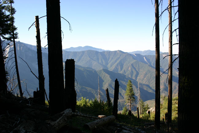
We're moving at a good pace, stopping for short but regular breaks, and staying hydrated. After a few hours, the forest spits us out at Eagle View, overlooking a 1000 foot drop into the Kaweah River Gorge. A few shallow creek crossings, various photo breaks, and a short lunch break later, we arrive at Bearpaw Meadow campground in the early afternoon. We're well ahead of schedule, but we know the next day is the one that killed us last time, so we take the time to relax and explore the camp. Bearpaw is a well-used campground, and has such luxuries as water taps and outhouses. It's shaded, and at 7,800 feet gets cold quite early. During the course of the evening we hear various hoots and hollers from the nearby privately-operate
 d Tent Hotel, to which we attribute a visit from a curious bear. After a few hours the aforementioned Brits make their entrance, all 21 of them. It turns out they are a group of officers from various British military services on a family building exercise. We had leapfrogged groups of them in the morning, and now took the time to make our formal introductions. Bed time soon comes around, and everyone retires to their little clearing to rest up for the next day.
Day two, and we're feeling stiff but ready for adventure. We're up early, but have a leisurely breakfast and pack quietly so as not to wake the snoring Brits. As we're heading out of camp, they start to lumber out of their tents, and gawk at the amount of gear they have to stuff back into their packs, or Bergens. (we hear this as "burgers" for the trip, but later discover that a Bergen is a kind of military rucksack.) We notice a few jealous glances at our small backpacks, and head out with a smile and a wave.
 Lunch time on day two is spent at arguably the most beautiful campsite on the trail, Upper Hamilton Lake. This was where we ended our backpacking last year, but this time we arrive before noon and in good spirits. For some reason we end up on opposite sides of the lake, but take the opportunity to have a quick ice-cold swim and a quiet lunch. One of our weight-saving methods is to cook most meals, including lunches. We enjoy the sunshine and tranquility for a half an hour, then psyche ourselves up for the trip over Kaweah Gap (10,700 feet).
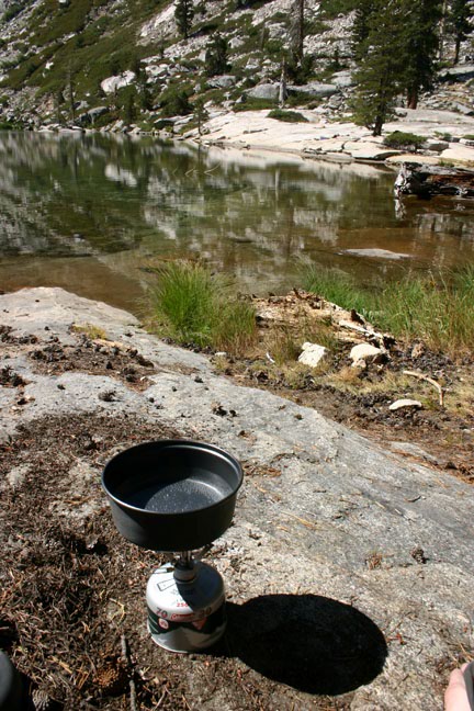
The march up to Prescipice Lake is one of my favorite parts of the trail. Each switchback
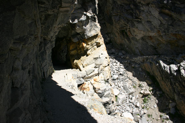
 shows you a slowly shrinking view of Hamilton Lake, a the first feeling of really being in the mountains hits you. A huge gorge reveals the remnants of an old suspension bridge, built in 1932, that was destroyed by an avalanche in 1937. Instead of replacing it, the talented Civilian Conservation Corps carved a shelf along the cliff edge, and somehow blasted a tunnel through the granite. Eventually we make it to the top of Kaweah Gap, and admire the view of Big Arroyo Canyon.
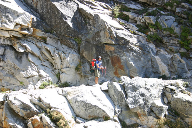
From here, there's nowhere to go but down. A few small lakes dot the rock strewn path, with small patches of green here and there. In the distance is what we assume to be our destination for the day, Big Arroyo Junction. The scenery on this side of the Gap is quite a contrast to the other side, with big open meadows interspersed with Sugar Pine forests. We're a bit tired at this point, and proceed in a one-foot-infront-of-the-other fashion. The day grows longer, but we're still not sure how much further it is to camp.
It turns out that Big Arroyo Junction is a lot further than we thought, and we arrive at camp quite late in the afternoon. Only one other person (Tim?) is there, and we become quick friends. Tim has lightweight backpacking down to an artform, and shows us his method of having all meals be perfectly square (not vitamin-wise, but geometrically) and weighing 1.5 pounds each. We gawk in amazement, and carefully put our plethora of ziploc baggies out of Tim's sight. We have a nice little fire and swap stories of life, the universe, and everything. We worry about where the Brits are, but not enough to keep us from falling asleep quickly.
 Day 3, and we're greeted by the first wave of Brits as we're packing up camp. It seems they couldn't figure out how far the camp was either, and ended up sleeping on the trail a few miles
  back. Today's hike is relatively short (8 miles) and takes us to Moraine Lake, an amazing camp site in the trees beside an equally amazing lake. We have plenty of time here to relax, swim, and do laundry, as we arrive shortly after lunch. We realize that we could quite easily cover more miles in a day, but opt not to adjust our itinerary. We've come to like the company of the Brits, and Rebecca isn't meeting us until day 7 anyway, so arriving early wouldn't serve any purpose.
Spririts have been fairly low among the Brits, with one soldier sitting on his pack and refusing to go on. Today's easier hike has lifted their spirits somewhat, and they enjoy splasihing around in the lake and spending a relaxing afternoon, their heavy packs forgotten for the time being.
On day 4 we're up with the sun, pause to snap a photo of the mist-covered lake, and on the trail early. Tonight's camp site is Kern Hot Springs, and the idea of a hot bath is foremost on our minds. We pass through a beautiful open marshy area, then plunge into a Jeffrey Pine forest as we proceed along the canyon. Early in the afternoon we arrive at Kern Hot Springs, which is exactly as promised. A roughly made cement bath tub, with plugs to control the flow of hot spring water, proves irresistable. We quickly set up camp, then each take our turns with a long soak in the tub. We want to make the most of it before 3 dozen soldiers have their go. Later in the evening, I have another soak or two after the Brits have finished their turn. Ian hopes to share a bath with Lynn, one of the prettier co-ed officers, but unfortunately it happens only in
 his imagination. We also discover that one of the troops has managed to spill honey inside her backpack, earning her the endearing nickname of Honeypants.
The hot springs did wonders for our sore muscles, and the next morning we are excited to get on the trail and explore new territory. The Brits made an early start, which gave us the opportunity for another quick morning bath before hitting the trail. At this point we noticed, a bit too late, that the campsite actually had a rough outhouse - alas, alas.
 We're now on day 5, and proceeding along the bottom of Kern Canyon. Even though there's no panoramic views from within the canyon, each corner brings new scenery and points of interest. The sides of the canyon range from 2000' to 5000', so we don't see the sun until close to lunch, when it quickly turns from cool to dry and hot. The Brits have arranged for a resupply via mule team at lunch time today, so we join in the excitement as they exchange huge loads of garbage for huge loads of food. We also take the opportunity to discreetly ask the Staff Seargant for some extra toilet paper. He politely shouts at the top of his lungs for someone to bring the Canadians some toilet paper. A couple of the young ladies comply, much to our embarrasment. They also invite us to load up on MREs (Meals Ready to Eat), where we grab a few treats to sample. I'm partial to the crackers and jam, and Ian is impressed by the single-use disposable camp stoves. Ah, military efficiency!
 In the afternoon we begin the ascent out of the canyon towards Junction Meadow, where the High Sierra Trail intersects with the John Muir Trail (our goal for 2008). At Junction Meadow we meet Brian, a US Marine who is nearing the end of a 3 week hike of the John Muir Trail. This turns out to be quite a busy camp site, and we make lots of new friends. There is plenty of room, and everyone finds a place to call home for the night.
Day 6 has us heading to Guitar Lake, the last campsite before Mt
 Whitney. We're starting to realize that our goal is within sight, and we're still feeling great. Our packs are now lighter than ever, with only a couple days' food left, we're acclimatized, and healthy. Ian is a bit worried about an ankle injury he got a few days prior, but one of the British medics provided him with a neoprene support and it's proving to be effective. The day is uneventful as we slowly gain elevation, and in the early afternoon we arrive at Guitar Lake. After finding a sheltered spot to set up camp (it's very windy at Guitar Lake) we proceed to do some exploring. We hike around for a few hours, and then head back to the camp site to greet the arrival of the army. The flat area around Guitar Lake is a sensitive alpine meadow, so the small camping area becomes densly packed with tents. With the close proximity of our neighbours, and the excitement of tomorrow's summit, we stay up later than normal telling jokes and stories with the troops. Fires aren't allowed at this elevation, so we wear everything we brought and stand around shivering. Eventually we go to bed, and drift off to sleep with dreams of sumitting Mt Whitney in the morning.
 It's summit day, and everyone is up extra-early for today's long hike. The trail quickly gains elevation, and switchbacks its way up the "back" side of Mt Whitney. After a few hours of hard work, we reach Trail Crest, where the spur trail to the summit turns off. Most hikers opt to leave their packs here and just take a snack and water up to the summit with them. There's no water to be had on the trail, so we have plenty with us. The packs are relatively safe to leave unattended as we're too high for bears, and the bear-cannister will deter any rodents. The trail becomes quite busy at this point, as we combine with day- and weekend-hikers from Whitney Portal. Everyone is exhausted but in high spirits as the summit gets closer and closer.
 We made it! The highest point in the continental US, 14,495 feet! We celebrate with a few photos, and a couple of shots of overproof rum, courtesy of some friends we made at the summit. We spend about an hour exploring and recouperating, then pry ourselves away to begin the descent. 20 minutes into our descent, we run into the Brits on their way up. It didn't take much taunting for them to convince us to join them going back to the summit. We really wanted a picture of ourselves with them at the top, so off we went, two summits in one day!
After two dozen pictures from two dozen cameras, we depart for the second time and head back
 to pick up our packs from Trail Crest. The long march down takes us past 100 switchbacks, and we're glad we didn't begin our hike at this end. Many people attempt it and fail, and we pass people still trying to attempt it, who will most likely be hiking home in the dark.
That night, we make camp at Trail Camp, a busy camp site with amazing views of the summit. Later in the evening, the Brits pass us, but decide to head further down to Outpost Camp to enable a shorter trip the next day. We're disappointed that we don't get to spend our last evening with them, and hope to catch them the next morning before they get picked up.
 The trip down to Whitney Portal was pleasant, and we past many hikers beginning their gruelling climb up. The downhill hike was very fast, and before we knew it we were at Whitney Portal Store, along with all the Brits. The biggest breakfasts we've ever seen are ordered, and we share a pancake the size of Rhode Island. Seriously, it was at least 3 feet across. I gained back the 10 pounds I lost on the trip in one meal. Shortly thereafter, the Brits get picked up and are whisked away to their next adventure.
Rebecca is meeting us at the nearby campground, so we go for a walk to see if she's there. It's still fairly early, so Rebecca hasn't arrived yet. We walk back up to the store where Brian, who is also getting picked up later in the day, teaches us some card games and swaps stories. We have a large lunch from the store, then begin to wonder why Rebecca isn't here yet. We invite Brian to join us on a walk to the campsite, where we eventually meet Rebecca, who cooks us all an amazing dinner. Brian gets ahold of his family and arranges for them to meet us at the camp site, so he can join us for the evening campfire. We're sad to be off the trail, but are still revelling in the accomplishment. We're now hooked on adventure, and know that we'll be coming back.
No comments:
Post a Comment